Browse Catalog
Product Description
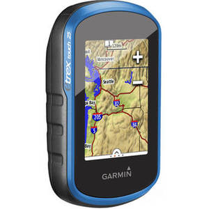
Whether you're actively involved in geocaching or just looking for a portable GPS unit to take with you on a hike into the woods or the urban jungle, the Garmin eTrex Touch 25 GPS Unit is sure to be useful. This easy to use navigation device will indicate your current position and lay digital breadcrumbs showing where you've been. The handheld GPS unit's 2.6" 65K color sunlight-readable screen displays your position in an easy-to-read manner. Control of all functions are simple, thanks to the touch screen You can attach this GPS to many different items with a variety of optional mounts.
This unit utilizes both GPS and GLONASS satellites for quicker signal acquisition so you get a fix on your position approximately 20 times faster than GPS alone. The receiver also can interpret Wide Area Augmentation System (WAAS) signals so you can receive information from terrestrial antennas even when your view of the sky is obstructed. The WAAS system also provides greater position accuracy overall. Adding to the GPS technologies, this device also features HotFix satellite prediction which uses an algorithm to mimic the movement of the Earth. This technology allows the receiver to quickly regain satellite connection after a couple days of non-use, eliminating long initialization times. A worldwide basemap is stored on the unit's internal memory so you will always have an idea of where you are.
The eTrex Touch 25 features built-in paperless geocaching software, so you can transfer your data to your computer with the supplied USB cord or upload it onto the Web. The unit's screen displays key information, including location, terrain, cache difficulty rating, and hints and descriptions of hiding spots. All of this means no more manually entering coordinates and paper printouts for your geocaching hobby. You can store up to 4000 waypoints on the receiver's built-in memory as well as 10,000 points, 200 saved tracks. A microSD card slot lets you load TOPO 24K maps for hiking, BlueChart g2 charts for boating, or City Navigator NT maps data for turn-by-turn routing on roads.
| Display Size | 1.4 x 2.2" (3.6 x 5.6 cm) |
| Display Size (Diagonal) | 2.6" (6.6 cm) |
| Display Resolution | 160 x 240 pixels |
| Display Type | Transflective, 65K color TFT |
| Runtime | 16 h |
| Stored Waypoints | Up to 1000 |
| Track Log | 10,000 points, 200 saved tracks |
| Altimeter | No |
| Compass | 3-Axis |
| Waterproofing | IPX7, temporary immersion |
| Cable Port | USB |
| Battery | 2 AA batteries (not included) |
| Dimension | 2.1 x 4.0 x 1.3" (5.4 x 10.3 x 3.3 cm) |
| Weight | 5.6 oz (159 g) with batteries |
Other items you might enjoy