Browse Catalog
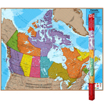
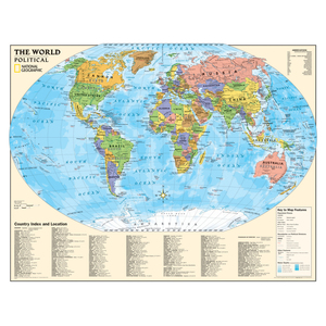
National Geographic Kids Political World Education: Grades 4-12 Wall Map, Laminated
Product Description
Political map of the world for grades 4-12. National Geographic's graded-series of maps are the first to address the unique needs of K-12 students as they advance their understanding of our World. Unlike other classroom poster maps, the world maps use the Winkel-Triple projection, which provides the best combination of size, shape, and distance giving the student the best visual representation of the Earth's surface in two dimensions. This solves the effect seen on other maps where Greenland appears larger than South America. Our Political Series, grades 4-12, has up-to-date World and U.S. maps, increasing the detail of information for the teacher and student to utilize. Scale: World map - 1:30,000,000. Size: 51" x 40".
- Our new graded-series of maps are the first to address the unique needs of K-12 students as they advance their understanding of our world
- Utilizes the Winkel-Triple projection, which provides the best combination of size, shape, and distance giving students the best visual representation of the Earth's surface
- Solving the effect seen on other maps where Greenland appears larger than South America
Specifications
Character
- Character: Non Character
Gender
- Gender: Unisex
Recommended Audience
- Recipient Ages: 8y, 9y, 10y, 11y, 12y, 13y, 14y, 15y, 16y, 17y, 18y
Shipping Dimensions
- length: 39
- width: 4
- height: 4
Other items you might enjoy